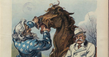
Looking a Gift Horse in the Mouth
Presented by the Cranberry Township Historical Society with the Cranberry Twp. Public Library in the Council Chambers of the Cranberry Township Municipal Building.
How often do you quote phrases that make no sense when you think about them? Come hear speaker Steve Cicero tell the stories behind these odd little idioms. These sayings have been around for years and some are home spun, while others have a direct meaning. These talks are not a dime a dozen. Steve is a former history instructor in the Butler Area School District, so he has been around the block. A leopard can't change its spots, but you can. So, on November 13th, please join Steve and the Cranberry Township Historical Society and get down to brass tacks, and find the history of some of these sayings. There's more ways to skin a cat, but why would you want to? Therefore, join us on Sunday, November 13th at 2:00 pm in the Cranberry Township Municipal Center's Council Chambers. Please feel free to bring one or two of your favorite sayings, but make sure you can share the meaning with everyone. Together, we will all try very hard not to bark up the wrong tree. This is a free talk for all to attend, and if you say you can't make it, well that just won't cut the mustard.
Event Date
November 13, 2022 - 2:00 pm
Event Location
Council Chambers
Cranberry Township Municipal Center
2525 Rochester Road
Cranberry Township, PA 16066
Cranberry Township Municipal Center
2525 Rochester Road
Cranberry Township, PA 16066