This survey was enumerated July 8th through July 19th of 1870 by S.M. illegible. Click on the column headings to sort them ascending or descending.
| # | First | Last | Sex | Age | Occupation | Page | Line |
|---|---|---|---|---|---|---|---|
| 01 | Joshua | Garvin | M | 38 | Cattle Dealer | 01 | 27 |
| 02 | George | McCaw | M | 32 | Dry Goods Merchant | 03 | 19 1 |
| 03 | Frank W. | Johnson | M | 21 | Clerk | 03 | 20 2 |
| 04 | Jacob | Crider | M | 46 | Farmer Renter | 03 | 40 3 |
| 05 | Pressly | Duncan | M | 22 | Hastener? | 04 | 16 4 |
| 06 | George | Coufer | M | 46 | Blacksmith | 04 | 22 5 |
| 07 | Henry | Butcher | M | 60 | Mail Contractor | 09 | 13 6 |
| 08 | Casper | Clase? | M | 24 | Stage Driver | 09 | 20 6 |
| 09 | Sidney | Stieler? | M | 19 | Stage Driver | 09 | 21 6 |
| 10 | William | Garvin | M | 27 | Trader or Tailor | 09 | 22 |
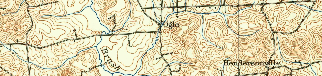
| 11 | Freeman | Graham | M | 61 | Miller Grist | 11 | 22 7 |
| 12 | Joseph | Shearer | M | 34 | Blacksmith | 11 | 30 8 9 |
| 13 | John | Donelson | M | 19 | Apprentice to Blacksmith | 11 | 37 9 |
| 14 | Theodore | Dichman | M | 61? | Preacher | 14 | 33 |
| 15 | Jacob | Kashner | M | 26 | Carpenter | 15 | 02 |
| 16 | James | Colon? | M | 26 | Painter | 15 | 14 |
| 17 | Andrew | Romigh? | M | 33 | Laborer | 16 | 06 |
| 18 | William | Ruby | M | 68 | Toll Gate Keeper | 17 | 16 10 |
| 19 | William | Russell | M | 50 | Stone Mason | 17 | 38 |
| 20 | Adam | Streeter | M | 50 | Boot & Shoemaker | 18 | 21 |
| 21 | John | Murray | M | 21 | Stone Mason | 19 | 32 |
| 22 | John | Little | M | 29 | Shoemaker | 21 | 12 |
| 23 | Henry | Stange? | M | 33? | Boot & Shoemaker | 21 | 26 |
| 24 | John | McAllister | M | 27 | Coal Digger | 22 | 28 |
- 1See G.H. McCaw store at Hendersonville on the 1874 map.
- 2Frank is living at the McCaw store and/or residence and is likely a clerk for G.H. McCaw.
- 3Listing shows a real estate value of $0 and personal estate value of $2,800.
- 4Ancestry interpretation of this is Farmer, but it looks more like hastener or possibly fastener.
- 5George Coufer is probably the father of blacksmith Frank P. Coufer on the 1880 census. Looks like Covfer. Ancestry translates it to Corfer. He would likely be staying at the BS shop in Hendersonville.
- 6 a b c Same household
- 7The grist mill is water-powered by Brush Creek and is located on Unionville Road west of Powell Road on the 1874 map. Real estate value is listed as $15,000.
- 8This BS shop is located adjacent to the grist mill. Real estate listed at $0. Probably renting from Graham.
- 9 a b Same household.
- 10Most likely working at a toll gate on the Perrysville & Zelienople Plank Road. Ruby is a landowner, but not listed on the 1874 map. The house on line 7 is the Hoffman residence with 9 occupants. A Hoffman appears across the road from the red brick Meeder farmhouse on the 1874 map. The next household following Ruby, is that of Thomas Robinson, which is the Ogle PO location on Dutilh Road.