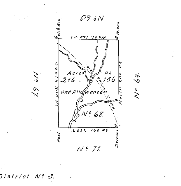
This is a copied survey of lot 68 of Alexander's part of District 3 of the Depreciation Lands.
On June 18, 1785, William Alexander, Deputy Surveyor (DS) and crew completed the first and original survey of lot 68 of District 3 of the Depreciation Lands. The survey indicates that the lot is 160 perches wide east to west. There are 16.5 linear feet to a rod or perch. The survey also indicates that the lot is 230 perches long on the north to south lines. The task was assigned to him by John Lukens, Esquire & Surveyor General (b: 1720 - d: 1789) of the State of Pennsylvania.
It is interesting to note how the 6% is calculated. If you calculate square perches and divide by 160 (square perches per acre), you get 230 acres. 6 percent of that, leaves 216.2 acres. If you take 6% of 216 acres and 156 perches (156/160), then add that, you arrive at 229.9935 acres, which fits the raw dimensions of the lot.
Between William Alexander and Samuel Nicholson, they surveyed about 85% of Cranberry Township as it is bound today (post 1854). Their surveys are in 8 columns of land. 7 of the 8 columns are 160 perches wide, while the western most column is only 152 perches wide. That western boundary, surveyed in 1785, remains the Beaver-Butler County line to this day. Many survey lines were planted and many of those tree line boundaries are visible today. A handful of roads serve in part as boundaries as well, as is the case with the northern boundary of lot 68 here, which is bound by the centerline of Glen Eden Road.
Note the dotted line passing through the lot. This is the Kuskusky Path. The old trail runs through the southwest corner of the golf course property. This path begins as a branch off of the Venango Path (which is part of Franklin Road in Cranberry today) in McCandless Township. That junction is visible on the 1914 Warranty Atlas of Allegheny County, a similar document of which is not known to exist for Butler County. The northern boundary of the 1914 Atlas does include the bottom portions of Butler County, enabling the numbering to be verified and sequenced when aligning 1785 boundaries onto a modern map. The path went to the Indian town of Kuskusky, which is New Castle today. The Venango trail connected Shannopin Town, which is Lawrenceville near the 40th Street Bridge today, to Venango, which is Franklin today.
Due to physical deterioration, this original survey was copied onto new paper in 1904, apparently 71 years after the decision was made to do so. It is possible that the act caused for the periodic recopying of these documents and we may be missing copies occurring in between.